Drought conditions expand across U.S.
7/17/2012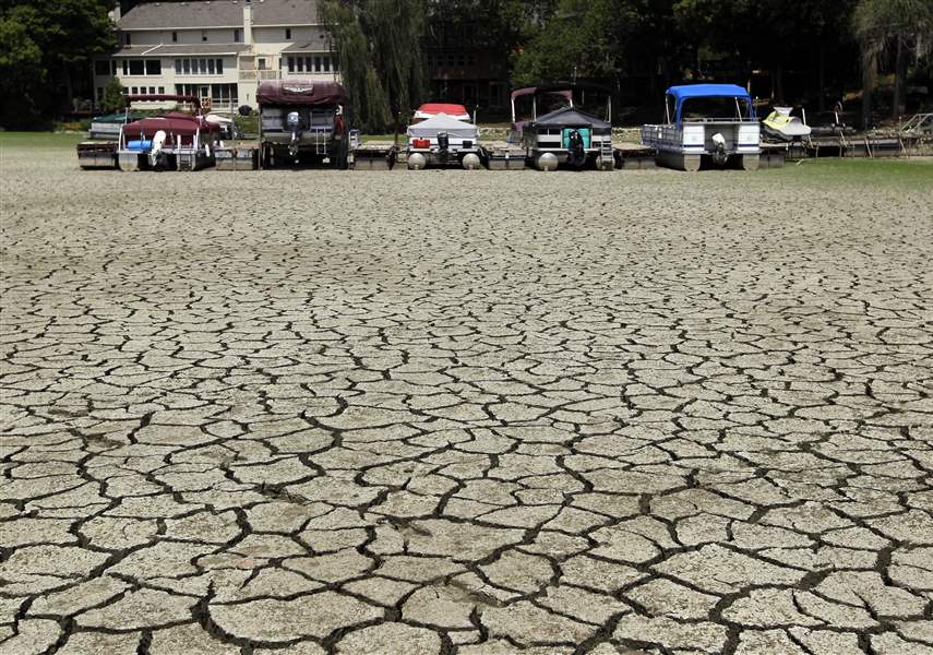
Boats sit on the bottom of a cove at Morse Reservoir in Noblesville, Ind. The reservoir that helps provide water to Indianapolis was down 6 feet from normal levels Monday, officials reported.
associated press

Boats sit on the bottom of a cove at Morse Reservoir in Noblesville, Ind. The reservoir that helps provide water to Indianapolis was down 6 feet from normal levels Monday, officials reported.
The nation's widest drought in decades is spreading, with more than half of the continental United States now in some stage of drought and most of the rest enduring abnormally dry conditions.
Only in the 1930s and the 1950s has a drought covered more land, according to federal figures released Monday.
So far there's little risk of a Dust Bowl-type catastrophe, but crop losses could increase if rain doesn't come soon.
In its monthly drought report, the National Climatic Data Center in Asheville, N.C., announced that 55 percent of the country was in a moderate to extreme drought at the end of June.
The parched conditions expanded last month in the Midwest, the Great Plains, and the West, fueled by the 14th-warmest and 10th-driest June on record, the report said.
Topsoil has turned dry and "crops, pastures, and rangeland have deteriorated at a rate rarely seen in the last 18 years," the report said.
The percentage of affected land is the largest since December, 1956, when 58 percent of the country was covered by drought, and it rivals even some years in the Dust Bowl era of the 1930s, although experts point out that this year's weather has been milder than that period, and farming practices have been vastly improved since then.

Cornstalks wither along North Fostoria Road near Woodville. Little to no precipitation is forecast until Monday.
About a third of the nation's corn crop has been hurt, with some of it so badly damaged that farmers have cut down their withered plants to feed to cattle.
As of Sunday, the U.S. Department of Agriculture said, 38 percent of the corn crop was in poor or very poor condition, compared with 30 percent a week earlier.
"This is definitely the epicenter -- right in the heart of the Midwest," said climatologist Mark Svoboda with the Nebraska-based National Drought Mitigation Center.
It's all a huge comedown for farmers who had expected a record year when they sowed 96.4 million acres in corn, the most since 1937.
The Department of Agriculture initially predicted national average corn yields of 166 bushels an acre this year.
The agency has revised that projection down to 146, and more reductions are possible if conditions don't improve.
Fears that the drought will get worse before it gets better have been pushing up grain prices. That is likely to translate into higher food prices for consumers, particularly for meat and poultry.
Monday's report was based on data going back to 1895 called the Palmer Drought Index.
It feeds into the widely watched and more detailed U.S. Drought Monitor, which reported last week that 61 percent of the continental United States was in a moderate to exceptional drought. However, the weekly Drought Monitor goes back only 12 years, so climatologists use the Palmer Drought Index for comparing droughts before 2000.

Climatologists have labeled this year's dry spell a "flash drought" because it developed in a matter of months, not over multiple seasons or years.
The current drought is similar to the droughts of the 1950s, which weren't as intense as those of the 1930s, said Jake Crouch, a climatologist with the National Climatic Data Center.
Farming has changed a lot since the Dust Bowl era. Better soil conservation has reduced erosion, and modern hybrids are much more resistant to drought.
But Mr. Crouch said it's important to understand that this drought is still unfolding.
"We can't say with certainty how long this might last now. Now that we're going up against the two largest droughts in history, that's something to be wary of," he said. "The coming months are really going to be the determining factor of how big a drought it ends up being."
In Ohio, conditions worsened during the last week, with the U.S. Drought Monitor reporting 78 percent of the state is under some level of drought. Severe drought conditions have taken hold along most of the state's western border, including all of Defiance County and nearly all of Paulding County.
Ohio's crop rating also continues to fall.
The U.S. Department of Agriculture said in its weekly crop progress report that 47 percent of Ohio's corn crop ranks poor or very poor for the week ending Sunday. In the report from a week ago, 36 percent of the crop fell into that designation.
Michigan ranked even worse, with 56 percent of its corn crop ranked poor or very poor, compared with 41 percent the week prior.
In general, farmers say fields to the east of Toledo are better than to the west, but rain has been lacking and sporadic across northwest Ohio.
Gary Baldosser, who farms in parts of Seneca and Sandusky counties, said he feels lucky when he compares his fields to photos from parts of Illinois and Indiana. Still, Mr. Baldosser said things are far from ideal.
"Last week was really hard on us. One hundred degrees tomorrow, no real rain forecast for the next week … this is going to get real critical for us," he said. "This week is probably going to be the end for some fields. Not all, but some fields. They're just not going to be able to make it."
Forecasters Monday predicted dry weather in the Toledo area today, with temperatures flirting with 100.
If reached at Toledo Express Airport, it would be the fourth triple-digit high there so far this summer and would break the July 17 record of 99, set in 1931 in downtown Toledo.
Before last year, when Toledo reached 102 degrees on July 21, the city had not reached 100 degrees since 1995.
The latest bout of heat was expected to break Tuesday night into Wednesday with a cool front accompanied by thunderstorms. The National Weather Service predicted a Wednesday high of 89, followed by a return of sunshine and mid-80s highs Thursday through Saturday.
Little to no precipitation is forecast again for the Toledo area until Monday, at which time the chance of rain is 30 percent.
The Toledo area has had 15.73 inches of precipitation since Jan. 1, which is 2.82 inches below this time last year. For all of 2011, the area logged 22.78 inches of precipitation.