Twister rips Van Wert County
4/2/2006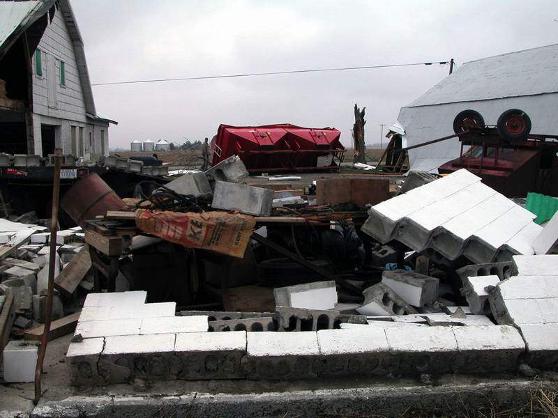
Cement blocks, overturned farm equipment, and a severed tree trunk display the damage done by the tornado that touched down south of Ohio City on Friday evening. On Gale and Jan Baker's farm, every building was damaged, and most of their farm equipment was destroyed.

No injuries were reported, but there was severe damage to the Gale and Jan Baker residence on Walnut Grove Road.
OHIO CITY, Ohio - A tornado ripped through a rural area of Van Wert County, just south of Ohio City, damaging homes, barns, and a factory during an outbreak of severe weather Friday night that swept across the Midwest.
Nobody was hurt and there was no estimate of the damage.
The Category F2 tornado touched down at 7:38 p.m. and, in just four minutes, created a path of destruction two miles long and 300 yards wide, according to the National Weather Service.
The tornado, with wind speeds between 113 and 157 mph, destroyed three barns, five outbuildings, a silo, and two vehicles. It damaged six homes, five other barns, farm machinery, three other silos, and caused a utility trailer to roll over.
The storm occurred at the end of Ohio's Severe Weather Awareness Week.
And it was a replay, too soon, of Nov. 10, 2002, when a tornado killed at least two in the county and flattened homes, factories, and, most notably, Van Wert Cinemas, where employees heard emergency broadcasts and led patrons to the safety of the restrooms moments before that twister hit.
Gale "Tim" Baker, 60, was inside his Liberty Township farm house Friday night when the tornado hit.
He didn't hear the often talked about freight train-like sound, but felt the wind shake his five bedroom home he's lived in for 58 years.

Cement blocks, overturned farm equipment, and a severed tree trunk display the damage done by the tornado that touched down south of Ohio City on Friday evening. On Gale and Jan Baker's farm, every building was damaged, and most of their farm equipment was destroyed.
"I thought it was going to blow a window out it was blowing so hard," he said. "It was some strong winds, and raining, and hailing, [but] it didn't last very long so I didn't think much of it."
That was until he went outside.
"I couldn't hardly believe it," he said. "I was like, 'Whoa, no.' I wasn't very happy to see all that mess. I don't think anything got missed."
All the buildings on his 1,000-acre grain farm were damaged, and several structures were leveled. Most of his farm equipment, including tractors and combines, were destroyed.
His home was spared heavy damage, save for the TV antenna falling on his house and some shingles and siding blown off.
The tornado was strong enough to lift nearby Baker Built Products, a welding business, off the ground. It was slightly damaged.
Rick McCoy, director of the county's emergency management agency, was tracking the storm with the help of about 40 spotters, including firefighters and amateur radio users.
They were recording winds up to 60 mph. The first bits of hail were reported about 7:15 p.m., but the pea-sized ice pellets soon grew to 1 1/4 inch by about 7:45 p.m.
Mr. McCoy said several people described a loud roar, rain going completely sideways, and the wind throwing things around in all directions.
"We knew we had a really good storm going through Ohio City because we had the large hail, but we never knew there was an actual tornado," he said.
The county was under a severe thunderstorm warning, but there was no alert of the tornado because nobody saw it, Mr. McCoy said.
When he got to the area about 8:30 p.m., he surveyed the damage and decided it was a tornado. National Weather Service personnel studied the area yesterday morning and confirmed the touchdown.
"There were multiple miniature tornados in the large tornado," said Mike Boguth, a meteorologist at the weather service office in North Webster, Ind. "It came together real quick and lasted for a couple minutes."
He said the weather service is studying what it could have done differently to give residents warning of the tornado.
"No one ever did see it in person and on radar there were some subtle clues that it was there," he said. "Sometimes with severe thunderstorms you can get brief tornadoes."
The storm entered the county near Kneller Road, where high winds damaged a barn roof and knocked over a corn crib. It went northwest to Walnut Grove Church Road and Burris Road just south of Ohio City, where the tornado touched down. It went east past Greenville Road before dissipating.
"You've got two miles of solid debris across the fields; all you can see is sheet metal and two-by-fours for the entire distance," Mr. McCoy said. "That's out in open country, in rural farms, which made it good. Nobody was displaced out of their homes."
Meanwhile, in Michigan's Lenawee County, authorities said there were reports of funnel clouds and a tornado touchdown.
However, the National Weather Service said last night that there were no tornadoes in southeast Michigan.
The large trees, utility poles, and power lines felled two and four miles southeast of Adrian, one mile east of Seneca, and two miles south of Jasper were brought down by straight-line winds that gusted to 65 mph, the weather service said.
The sheriff's office activated a cable television alert system about 7:10 p.m., informing residents with a text message on the bottom of their TV screens that there was a tornado warning.
About 500 residents were without power Friday night.
In Monroe County, there were reports of trees down in Maybee and Ida.
Warm air that flowed into the region Thursday and during the day Friday was followed by a strong cold front that swept across the area Friday evening. The clashing of the two air masses touched off the outbreak of severe storms, the weather service said.
The temperature in the Ohio City area late Friday afternoon was in the upper 60s; yesterday afternoon it was in the upper 40s, the weather service said.
The November, 2002, tornado was part of a storm that killed at least five and injured more than 25 in northwest Ohio. Van Wert and Ottawa counties were hit particularly hard, although President Bush declared six northwest Ohio counties disaster areas.
A tornado in May, 1998, formed over Van Wert County's Hoagland Township, traveled northwest, and crossed into Paulding County, damaging a barn.
Six people were hurt and five houses were damaged or destroyed by a tornado Feb. 18, 1992, near U.S. 127 and State Rt. 81 in Van Wert County.
Nearly 200 homes were destroyed and 18 people injured March 27, 1991, when a tornado touched down sporadically over a six-mile course near Nettle Lake in Williams County. In Hillsdale County, a tornado - possibly a spinoff - injured three.
Tornadoes June 10, 1986, southeast of Defiance, demolished six homes and downed power lines.
A tornado April 11, 1965, was the worst in Toledo's history, cutting a 10-mile swath from West Toledo to Maumee Bay, killing 15 in Point Place and 35 others across the Ohio and Michigan countryside. The deadliest tornado in Ohio was June 28, 1924, when a twister started in Sandusky and traveled east toward Lorain, killing 72. The tornado's toll has been estimated at 85 deaths.
Blade staff writers Mike Bartell and Mark Zaborney contributed to this report.
Contact Meghan Gilbert at: mgilbert@theblade.com or 419-724-6050.