Fresh snow blankets Toledo area
2 new inches push city above annual average already
1/17/2014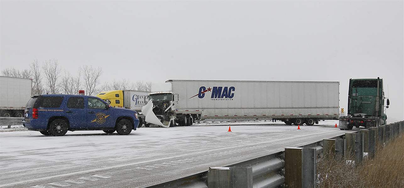
Traffic moves at a crawl in one lane on southbound I-75 near Bay Creek Road in Erie after a tractor-trailer jack-knifed. Crashes, including one fatal, were reported across the area Thursday.
THE BLADE/ANDY MORRISON
Buy This Image

Brett Gillespie looks over the ice jam behind his Wood County home on the Maumee River, off State Rt. 65 near Range Line Road.
While most Toledo-area residents dealt with a fresh round of winter weather Thursday, those who live along the Maumee River kept on alert for lingering consequences from the last storm.
A fast-moving storm delivered a quick two inches of snow at Toledo Express Airport during the afternoon, bringing the official snowfall total to date for this winter to 38.1 inches — half an inch more than Toledo receives for an entire average winter.
The snow contributed to a fatal collision on the Ohio Turnpike in Fulton County and to numerous less-severe crashes elsewhere in the region.
PHOTO GALLERY: Snow returns to Toledo area
Christopher Gasper, 26, of Orland Hills, Ill., died after he lost control of his car on the turnpike’s snow-covered westbound lanes near the State Rt. 66 interchange north of Archbold about 2:14 p.m., troopers at the Ohio Highway Patrol’s Swanton post reported.
Mr. Gasper’s car collided with another car, then was hit by a tractor-trailer, sending his car into a ditch. The other car’s driver was not hurt, while truck driver William T. Jackson, 50, of Cleveland, was taken to Fulton County Health Center in Wauseon for treatment of injuries troopers said were not life-threatening.

Traffic moves at a crawl in one lane on southbound I-75 near Bay Creek Road in Erie after a tractor-trailer jack-knifed. Crashes, including one fatal, were reported across the area Thursday.
A pickup-semi collision Thursday afternoon in Monroe County, meanwhile, left a Monroe woman critically injured.
Jessica Maney, 28, was northbound in the center lane when she lost control and her spinning pickup was struck in the driver’s-side door by a tractor-trailer driven by James Provins III, 49, of Macomb, Mich., Monroe County Sheriff’s deputies said.
Ms. Maney was taken to Oakwood Southshore Hospital in Trenton, Mich. Mr. Provins was not injured.
Crashes in Toledo were mostly minor, but one closed a lane on southbound I-75 near downtown for several hours when a semi’s ruptured fuel tank spilled diesel.
Along the Maumee near Grand Rapids, Ohio, the big issue was flooding from an ice jam that formed earlier this week about a mile upstream of the Grand Rapids Bridge.
The National Weather Service extended a flood warning for the river from Henry County’s eastern border to Lake Erie until 9 a.m. today because of the possibility the ice jam would break and cause a rush of water downstream.
Marty Mullen, a meteorologist at the weather service’s regional office in Cleveland, said Thursday night he expected that warning to expire today because increasingly cold weather makes it unlikely the jam will break up.
But snow is likely to continue, Mr. Mullen said, “just enough to be slippery.”
“It’s just another [Alberta] Clipper,” he said of the snow that fell Thursday.
The storms are so named because they form over western Canada and dive south around a low-pressure circulation over the Great Lakes.
“We’ve got a series of them that are going to affect us through the weekend. It doesn’t look like any of them is going to be a big snowmaker, but they’re going to be a nuisance 1 to 2 inches,” Mr. Mullen said.
Along with pushing Toledo’s season-to-date snowfall past the average total, Thursday afternoon’s 2 inches moved this month into fourth place on the list of snowiest Januaries, with 26.4 inches. Another inch was possible by morning.
Toledo’s snowiest January on record was in 1978, when 30.8 inches fell at the airport.
Mr. Mullen said there were two or three more small storms headed toward the lower Great Lakes. After that, he said, Toledo-area temperatures are expected to take another dive early next week, though not as low as they were early last week when the mercury at Toledo Express dipped as low as -15, and with not as much wind, either.
Last week’s cold created ice about a foot thick on the Maumee, which then broke up over the weekend when temperatures warmed and rain fell.
Ice jams form when ice chunks floating downstream reach a constriction point — such as a river bend, sand bar, island, or bridge — and jam together there.

Liz Geniac works to brush the snow off of her car on North Superior Street near Madison as she leaves one job to head to another.
For the past few days Brett Gillespie has watched from his riverfront home in Wood County’s Washington Township while ice chunks have piled onto each other and into the lowland part of his property, which is near some islands in the river.
Mr. Gillespie isn’t worried about his home, but was surprised how close the ice got to his boat, which he thought he had left a safe distance from the water, and a tree he planted a few years ago.
“My house is up high enough that if it takes my house, it’s going to take Toledo,” he quipped.
But friction between the ice and the shore is a big erosion factor, “and the heave was bigger than I’ve ever seen” in five years living there year-round.
Five years ago, Mr. Gillespie said, it was cold enough for the Maumee to freeze over before Christmas, but it stayed that way until March.
This season, it has already frozen and thawed twice, and after the first freeze in December, he said, Auglaize River floodwaters that had inundated parts of Findlay and Ottawa brought impressive debris downstream to the Maumee.
“Trees the size of submarines came by,” he said. “I wonder where they ended up.”
Contact David Patch at: dpatch@theblade.com or 419-724-6094.