Major flood hits Findlay, closes highways, streets
No big evacuations necessary, leaders say
12/23/2013
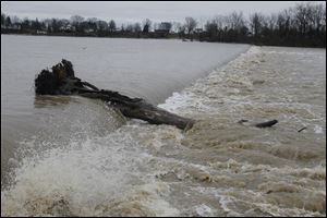
An uprooted tree is swept over the Grand Rapids Dam at Mary Jane Thurston State Park in Grand Rapids, Ohio. The Maumee River was at flood stage only at Waterville Sunday evening, it was expected to rise today. Flooding was expected to be moderate at Grand Rapids and Waterville.
FINDLAY — Significant parts of Findlay remained under water Sunday evening and numerous state highways were closed across northwest Ohio because of flooding from heavy rain Saturday afternoon and evening.
The Blanchard River and Eagle Creek in Findlay were in major flood status, with many city streets closed as of Sunday evening, but Ron Rooker, the disaster program manager for the Red Cross of Northwest Ohio, said the water was still below levels needed to force significant evacuations.
The agency opened an emergency shelter Sunday morning at Glenwood Middle School.
Luke Routzon, shelter supervisor for the American Red Cross of Hancock, Seneca, and Wyandot Counties, said nine people, which included three families, took advantage of the shelter Sunday.
The Red Cross planned to place the nine in a motel and close the school Sunday evening, he said.
The people who evacuated their homes were prepared to leave before the flooding advanced, Mr. Routzon said.
“The good news is that the flood predictions have decreased from the initial numbers,” Mr. Rooker said. “I’m not saying we dodged a bullet, but the need for evacuations is less than anticipated.”
City officials spent the day shifting barricades around as various streets needed to be closed or were able to reopen, and the Ohio Department of Transportation said many state highways in the surrounding area were under water.
At midday, the Blanchard River’s height had reached 13.9 feet, rising into the major-flood stage, which is 13.5 feet.
Highways closed near the city included U.S. 68 on the south side, State Rt. 568 to the northeast, and State Rt. 37 to the southeast. U.S. 224 was closed both in Tiffin and west of Ottawa, Ohio; U.S. 23 was closed in Carey, north of its junction with State Rt. 15, and State Rt. 18 was closed at Tarr Street in North Baltimore and near Milton Road east of Deshler.
Farther north, State Rt. 19 was closed at a flood-prone spot just south of the Ottawa-Sandusky county line, but State Rt. 105 along the Portage River west of Pemberville had reopened after being closed earlier in the day.
As of 5 p.m. Sunday, the National Weather Service reported the Blanchard River was 3.5 feet above its 11-foot flood stage at a gauge downriver of Findlay, while Eagle Creek on the city’s east side was 2.2 feet above its 9.0-foot flood stage.
Eagle Creek was holding steady and expected to retreat to its banks by morning, but the Blanchard was forecast to rise to 15.7 feet before cresting. Mr. Rooker said it would need to reach 16 feet to cause widespread evacuations.
Downstream in Ottawa, the Blanchard was 3.8 feet above its 23-foot flood stage at 5 p.m. Sunday, and it was expected to rise to 28.9 feet — about the level when widespread flooding occurs in the downtown area. Forecasters said flood conditions near Ottawa were likely to persist into Wednesday.
The weather service reported 2.77 inches of rain fell at the Findlay airport between midnight Saturday and sunrise Sunday, with a full inch of that falling between the 8:53 p.m. and 10:53 p.m. readings Saturday night. The ground had been saturated by melted snow from a storm a week earlier plus lighter rain on Friday.
But the heavy rain and resulting flooding were well-forecast, with flood watches posted Friday and forecasters warning about the potential several days before that.
Lima got slightly more rain, 2.81 inches, but is not as flood-prone as Findlay is. The weather service reported Saturday-Sunday rainfalls of 1.48 inches in Defiance, 1.76 inches in Toledo, and 0.81 inch in Adrian.
Forecasts Sunday night called for rain or snow showers overnight followed by freezing drizzle or snow showers today and Tuesday, but nothing heavy enough to contribute to flooding. Snow accumulations of less than an inch were possible in Toledo and Findlay.
While the Maumee River was above flood stage Sunday evening only at Waterville, it was expected to rise through the day today, and flood at gauges in Defiance, Napoleon, and Grand Rapids as swollen tributaries, including the Blanchard, Auglaize, Tiffin, St. Joseph, and St. Mary rivers, fed their waters into it. Flooding at Defiance and Napoleon was forecast to be minor but moderate at Grand Rapids and Waterville.
Moderate flooding also was expected on the Portage River, where part of South Cherry Street in Woodville was expected to be under water at crest late Sunday. The Huron River was expected to return to its banks late today after cresting overnight 4.2 feet above its flood stage in Milan, Ohio.
Along the Sandusky River, moderate flooding was reported near Tiffin, but only minor flooding was expected in the Fremont area, where the flood was expected to end Tuesday morning.