Heavy rains replace snow as winter’s latest hazard
2/21/2014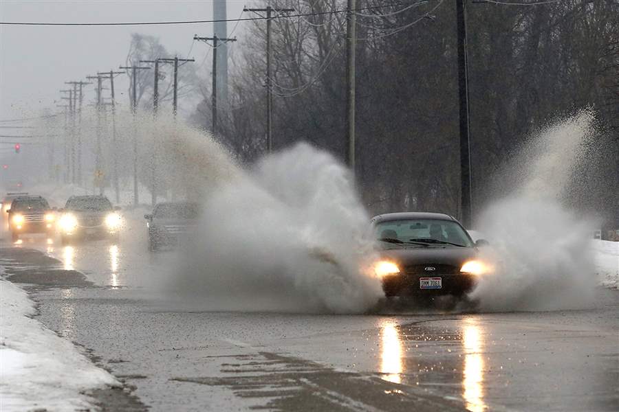
Plumes erupt from cars passing through water on Sylvania Avenue near Centennial Road in Sylvania Township, the result of melting snow and rainfall.
THE BLADE/KATIE RAUSCH
Buy This Image

Plumes erupt from cars passing through water on Sylvania Avenue near Centennial Road in Sylvania Township, the result of melting snow and rainfall.
Heavy rain in the Toledo area on Thursday that flooded streets and basements may have been a factor in sinkholes that closed part of Sylvania Avenue, and caused a partial roof collapse at a Napoleon cold-storage warehouse.
But most of the rain fell away from northwest Ohio rivers that have been prone to flooding, leaving only a “moderate” flood probability in Hancock and Huron counties, according to the National Weather Service.
Instead, street and urban flooding was the big issue with the inch or more of rain that fell on Toledo between 8:30 a.m. and 12:30 p.m. Thursday.
The weather service said 1.42 inches fell at Toledo Express Airport and 1.15 inches at Toledo Executive Airport in Lake Township.
Storm drains clogged with snow, slush, or ice left the water with nowhere to go and it ponded on streets and highways. Water covered parts of I-475 in West Toledo and the Ohio Department of Transportation briefly closed the Douglas Road entrance to eastbound I-475 to clear clogged drains.
The westbound lane of West Sylvania Avenue was closed between Burnham and Vermaas avenues after two sinkholes developed.
Lisa Ward, a city spokesman, said the sinkholes’ cause and extent were being evaluated Thursday evening.

A cold front will sweep through northwest Ohio and southeast Michigan today, and the National Weather Service has issued wind advisories for the entire region.
Similar voids elsewhere typically were caused by sewer collapses after heavy rain washed out soil.
Potholes continued to plague city thoroughfares. At least 10 cars fell victim to a hole on the Anthony Wayne Trail outbound ramp to southbound I-75 late Thursday before police cordoned off the pothole with orange cones.
The rain, which started in Toledo as sleet and in parts of southeast Michigan as a wintry mix that included snow, moved into the region ahead of a warm front associated with a vigorous storm system in the lower Great Lakes.
Jay Berschback, chief meteorologist at WTVG-TV Channel 13, said the front stalled over Lucas County, causing the heaviest rain to fall in and near Toledo.
The warm front moved north Thursday evening, ushering in warmer temperatures before the storm’s cold front swept across the area early today.
That frontal passage, to be accompanied by a line of thunderstorms with brief heavy rain, was forecast to be followed by chillier air and gusty winds, for which the National Weather Service posted advisories effective for the entire area today.
Mr. Berschback said that while snow contributed to street flooding, it may have soaked up some of the rain that otherwise might have run off over frozen ground and flowed into rivers, where it could have caused significant flooding.
But snow on roofs also soaked up the rain, making that snow heavier.
At Cloverleaf Cold Storage in Napoleon, a snow-laden roof on a loading dock collapsed, breaking pipes for the ammonia the warehouse uses as a refrigerant.
Eleven people were evaluated for ammonia exposure after the accident, with three taken to Henry County Hospital for minor injuries, Napoleon police Chief Robert Weitzel said. None were identified, and at least two were released within a few hours.
An ammonia plume prompted evacuation of the Henry County Humane Society across Independence Drive from the warehouse. Chief Weitzel said no animals in that building were injured.
Denise Keller, assistant area director of the Occupational Safety and Health Administration’s Toledo Area Office, said OSHA was investigating the incident.
Bill Feiges, a company principal officer from Cloverleaf headquarters in Sioux City, Iowa, said more than 100 people work in the building, which is used for meat processing.
He said the ammonia leak was reported and contained.
Mr. Feiges did not know how much gas escaped nor did he have a cost for the damage. He said the incident likely did not damage any product.
A company statement said the main cold-storage warehouse was undamaged and not affected by the ammonia leak, and the insulated facility was expected to remain cold enough to meet food safety thresholds until power was restored to the refrigeration system.
In Findlay, where just 0.3 inch of rain fell during the morning, the National Weather Service issued a flood warning for the Blanchard River.
Snow melt and storm runoff was forecast to lift the Blanchard by more than 10 feet, to about 1.2 feet above its 11-foot flood stage in Findlay, by midday today.
Paul Schmelzer, Findlay’s safety and service director, said that as long as no ice jams developed, flooding would not be a big problem.
“A 12-foot flood, that’s certainly something we’re able to deal with,” he said.
Findlay received more significant flooding just two months ago from another post-snowstorm thaw, he said.
The other area river with a flood warning Thursday evening was the Huron, which the weather service also said would go into “moderate” flooding today after a 10-foot rise.
Although no flood warning was posted for the Portage River as of 8 p.m. Thursday, Pemberville Mayor Gordon Bowman said he expected some minor flooding.
“We won’t know for sure until the rain tonight,” he said Thursday afternoon.
While ice jams remained a concern, Mr. Bowman said warmups Tuesday and Wednesday ahead of the storm had been helpful by softening and thinning the Portage ice.
A flood warning remained in effect for Henry, Fulton, Williams, and Defiance counties, as well as neighboring parts of Indiana, for localized and small-stream flooding.
In Lenawee County, Sheriff Jack Welsh issued a travel advisory cautioning motorists about standing high water on many rural roads.
“It is impossible for the road commission to place signage on every road that may have areas of high water,” the sheriff warned. “We are asking motorists to drive with caution when approaching areas of high water. Detour around those flooded areas. Do not risk getting stranded in the high water.”
Except for a city crew that milled pothole-pocked pavement off the Anthony Wayne Trail’s outbound right lane near City Park Avenue, the rainy day shut down city and state efforts to repair winter-ravaged roadways.
Road repairs were expected to resume today. ODOT said it would send crews to northbound I-75 between the I-475 junction in Perrysburg and U.S. 20; I-475 between U.S. 24 and Central Avenue; I-75 between U.S. 6 and State Rt. 18 in southern Wood County, and U.S. 6 between the Henry-Wood county line and I-75.
Work in those areas was expected to occur between 7 a.m. and 7 p.m. More pavement repairs are planned for Saturday.
Staff writers Vanessa McCray and Janet Romaker contributed to this report.
Contact David Patch at: dpatch@theblade.com or 419-724-6094.