Ohio Senate OKs redistricting plan
9/21/2011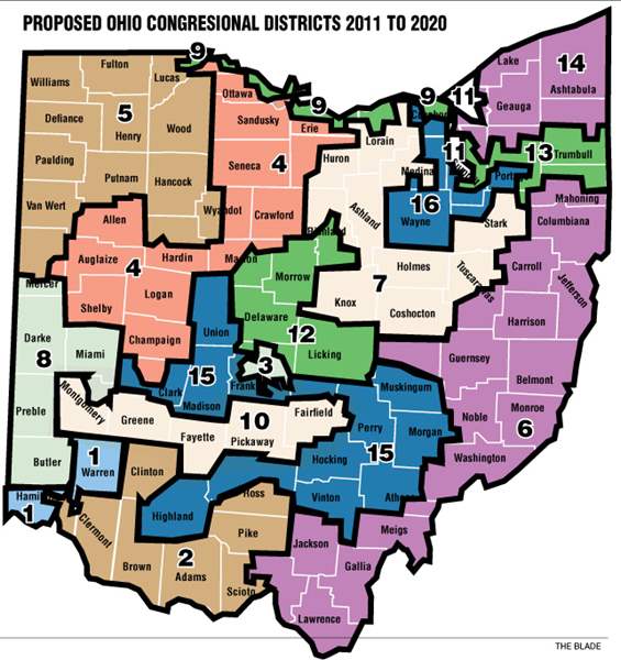

COLUMBUS — The Ohio Senate Wednesday voted 24-7 to rubber stamp a proposed congressional map that slices the city of Toledo between three districts.
The House was waiting in the wings to ratify changes made to the bill that was, in part, designed to sidestep a voter referendum threatened by Democrats. The map is likely destined for a court challenge.
Hours before the vote, Toledo Deputy Mayor Tom Crothers urged lawmakers to change course, arguing that Toledo will not be well served by slicing it into three congressional districts, two of which would be primarily rural.
“I implore you to base your decision whether to support HB 319 in its present state upon what is best for the citizens of Ohio,’’ he told the Senate Government Oversight and Reform Committee. He argued that the map would make Toledo “politically irrelevant.’’
Toledo City Council unanimously adopted a resolution Tuesday in opposition to the proposed map.
“…(I)t divides six Ohio counties into three or more districts and in the City of Toledo creates a district that would allow for the representative for downtown Toledo to live over 100 miles from the city center, and two other districts where Toledo residents living in the same neighborhoods of South Toledo would have different congressional representation…,’’ reads the resolution.
But Sen. Mark Wagoner (R., Ottawa Hills) argued later on the Senate floor that divided representation may not be “altogether a bad thing.’’
“First, it would give us more clout in Congress,’’ he said. “Three voices are better than one. Second, it would require bipartisan cooperation from Congress to move our area forward… It is incumbent by all of those three to work together and put politics aside.’’
Sen. Edna Brown (D., Toledo) didn’t see it that way.
“This map is an outrageous example of gerrymandering…,’’ she said. “This map does not represent Ohio history as a 50-50 battleground state… The acceptance of this map not only marginalizes Toledo residents’ votes, but also dramatically weakens our voices.’’
Under the map, Toledo would be divided between the 9th District held by U.S. Rep. Marcy Kaptur, of Toledo; the 5th held by U.S. Rep. Bob Latta, a Bowling Green Republican, and the 4th District held by U.S. Rep. Jim Jordan, an Urbana Republican. The latter district encroaches on Lucas County from the east, picking up downtown Toledo and stretching as far south as Springfield.
Ms. Kaptur’s 9th District would snake thinly along the Lake Erie shoreline from Toledo to Cleveland, pitting her in a 2012 primary battle with another veteran Democrat, U.S. Dennis Kucinich.
Just before forwarding the bill to a full chamber vote, the Republican majority on the committee added $2.75 million to help county boards of elections to implement the new maps. Democrats opposed the last-minute amendment, knowing that its addition may have put the new map out of reach of a voter referendum.
Unless a court disagrees, the appropriation would ensure that the bill would take effect immediately upon the signature of Gov. John Kasich. The bill assumes that the 2012 presidential election will be held on March 6. Lawmakers have apparently shelved a proposal that would have delayed it until May.
All Republicans supported the bill, and they were joined by two African Americans who were pleased with how the map preserves a black majority district straddling Cleveland and Akron and creates an opportunity for a black candidate in a new Columbus-based district that would be solidly Democrat.
Contact Jim Provance at:
jprovance@theblade.com
or 614-221-0496.