Commentary
200 years ago, lake’s look was much different, cleaner, teeming with fish
9/1/2013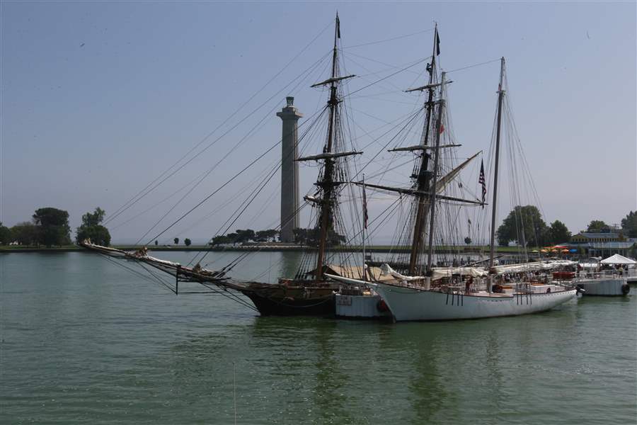
A reconstruction of the warship US Brig Niagara, left, and the Halie & Matthew, named for the children of its builder, Capt. George ‘Butch’ Harris, of Eastport, Maine, arrived Thursday at Put-in-Bay, Ohio, in anticipation of Monday’s re-enactment of the decisive War of 1812 battle in Lake Erie.
THE BLADE/AMY E. VOIGT
Buy This Image

A reconstruction of the warship US Brig Niagara, left, and the Halie & Matthew, named for the children of its builder, Capt. George ‘Butch’ Harris, of Eastport, Maine, arrived Thursday at Put-in-Bay, Ohio, in anticipation of Monday’s re-enactment of the decisive War of 1812 battle in Lake Erie.
PUT-IN-BAY, Ohio — With the Battle of Lake Erie bicentennial celebration enveloping the Lake Erie Islands this weekend, the wide natural harbor here is heaving with boats — sailboats, yachts, pleasure boats, high-performance race boats, ferries, and the tall ships that will take part in Monday’s re-enactment of that decisive War of 1812 naval encounter.
The crush of people, the commerce, and the development spread across South Bass Island’s 1,600 acres surrounding the bay are part of what makes this a radically different place than Comm. Oliver Hazard Perry and his men found when they arrived here 200 years ago.
On or about Aug. 15, 1813, Commodore Perry is believed to have moved his fleet into the harbor to await the impending confrontation with the British. Dr. Usher Parsons, a surgeon traveling aboard the Brig Lawrence under Perry’s command, made this entry in his journal marked with that date:
“Sund’y. Rained. Passed Sandusky harbour and anchored among Islands, -two dwelling homes on one of them.”
What Dr. Parsons described is very likely South Bass, the home today of vineyards, a busy marina, an airstrip, the brisk tourist trade of bars, restaurants, and shops in central Put-in-Bay, and hundreds of cottages and year-round residences. His journal account closely matches what historians believe Commodore Perry and his men would have seen as their ships moved close to the island and their date with history.
Tenant farmers had been sent over by the island’s owner, Judge Ogden Edwards of Connecticut, who had purchased a number of the Lake Erie Islands. In 1811, and after clearing a small section of land, the farmers planted wheat. They hauled their harvested crop to Catawba on the mainland for storage, but it was raided there and burned by the British and their Native American allies, according to island historian and author Amy Newell-Huston.
“The farmers evacuated once the hostilities started, and they left their livestock behind, including pigs,” Ms. Newell-Huston said. “So Perry and his men likely found a couple of dwellings that had been used by the farmers, but other than the small area used to grow the wheat, most of the island was likely woods at the time. There would have been very little development.”
French explorers and fur traders are believed to have visited South Bass during the late 1700s, using it as a rest stop on travels across the lake, and the Lake Erie Islands appeared on some of their early charts, according to historical entries at the Putinbay.com Web site.
South Bass’ first human visitors were likely Native Americans, who could have crossed here on the ice to hunt. Arrowheads, pieces of flint, and stone axes have been unearthed during construction work.
Maps from the period when Commodore Perry sailed Lake Erie refer to the harbor as “Pudding Bay,” since it apparently resembled the shape of a pudding bag, or tote.
“At some point, that name morphed into Put-in-Bay, but nobody is really sure how, or when,” said Dan Savage, director of the Lake Erie Islands Historical Society.
Commodore Perry and his men are believed to have spent about a month on and around the island, preparing and waiting for the battle with the British fleet that would take place on Sept. 10, 1813, in the open lake to the west.

An Aug. 20 journal entry by Dr. Parsons references a cave on the island that could be what is known today as “Perry’s Cave.” The American sailors used the cave as a source of safe drinking water after becoming ill consuming lake water that was likely laced with bacteria.
Aug. 20: “Friday. Fired a salute. The principle [sic] officers went to put-in bay to examine a cave. I went on shore on a peninsula in the afternoon, found a foot path which we followed one mile through to woods and arrived to an orchard. There had been nearly a dozen settlements at the time war was declared, when the inhabitants were massacred by indians [sic] and their habitations burned. The body of one man more recently dead was found scalped. Brot [sic] off some apples, pigs, &c.”
In a later entry, Dr. Parsons made a reference to health problems that were very likely associated with drinking lake water: “... Mr. Smith very unwell. Commodore sick.”
On the military side, Dr. Parsons’ Aug. 16 entry stated that while several smaller vessels in Commodore Perry’s fleet were out on the lake between the islands and Sandusky, they spotted an unidentified sail about eight miles in the distance, and gave chase until they ran out of daylight and one of the gunboats ran up on a shoal. His “boisterous wind all night” entry would come as little surprise to modern Lake Erie boaters.
About 10 days after that entry by the surgeon, Samuel Hambleton, who served as acting lieutenant on the Brig Lawrence, referenced a reconnaissance mission that took his ship to Malden, the Detroit River site of the British Fort Amherstburg.
“Wednesday. We did not arrive off Malden until this morning,” he wrote. “After viewing their force, at anchor, for several hours we stood down the Lake & came to anchor before night in Put-in-Bay, 30 miles below Malden. In this neighborhood the Pilot reckons 30 islands.”
That was a fairly accurate count of the islands, if one includes the very small bodies like Starve Island that are little more than exposed reefs. Commodore Perry is believed to have used the highest vantage point on the islands, on tiny Gibraltar Island located in the South Bass harbor, as a lookout to see the approaching British fleet.
The Lake Erie that he and his men sailed 200 years ago was also a dramatically different body of water — no industrial pollution, no municipal sewage-system overflows, no major algae issues associated with agricultural runoff, and no invasive fish or shellfish.
“It was absolutely a very different lake from what we see today. The presumption is that the western basin would have been dominated by strong populations of walleye and perch, along with smallmouth bass,” said Jeff Tyson, who heads the Sandusky Fisheries unit of the Ohio Division of Wildlife.
Mr. Tyson said Lake Erie in the early 19th century also would have experienced autumnal mass migrations of lake herring and whitefish, with those two historically prevalent species moving from the deeper, colder portions of the lake into the Western Basin’s shallow bays, reefs, and island areas to spawn.
Both species were later grossly overfished, with lake herring being Lake Erie’s most important commercially harvested species at the start of the 20th century, when close to 50 million pounds were hauled out in one year.
Lake Erie’s whitefish suffered a similar fate. Today, there remains a limited commercial fishery for whitefish and a slowly recovering population, while the lake herring, or cisco, is so rare it is listed as endangered.
Mr. Tyson said the lake Commodore Perry plied most likely would have had lake trout spawning around the islands, and hatches of mayflies would have been prevalent.
“We can presume that at the time the Battle of Lake Erie took place, the lake supported a much more stable fish community than we see now,” he said.
The water likely looked different in the areas around Sandusky Bay and Maumee Bay too, Mr. Tyson said, because of decaying vegetation from the Great Black Swamp, which covered a vast area of what today is northwest Ohio.
“The lake water in those bays would have been stained darker, due to the tannins coming from all of that swampland, but the lake certainly would have been healthier in general,” he said.
The swamp’s near impenetrability made the Battle of Lake Erie crucial to the war’s outcome, Ms. Newell-Huston said.
“Due to the presence of the Great Black Swamp, the lake presented the only real trade route,” she said. “So this region and these islands had great strategic value.”
Before Commodore Perry’s arrival, South Bass Island was known briefly as Ross Island, possibly reflecting the name of a squatter who had stayed there. Squatters are believed to have visited the island to cut firewood for the steamships that sailed the lake at the time. At some point, nearby Middle Bass Island was called Isle des Fleurs — Island of Flowers — by the French, while North Bass Island was known as Isle Saint George.
Contact Blade outdoors editor Matt Markey at: mmarkey@theblade.com or 419-724-6068.