Flooding fears rise after wet and windy storms sock south-central U.S.
3/20/2012
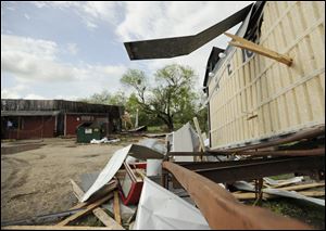
High winds propelled this piece of wood through a sign in front of Charlie's Ice House in Devine, Texas. The neighborhood bar was damaged when a tornado touched down Monday night in the town of 5000, about thirty miles southwest of San Antonio.
OKLAHOMA CITY — Residents and businesses from southeast Texas north through western Missouri braced for flooding Tuesday after a violent band of storms brought heavy rain, hail and at least one tornado, with more of the same forecast for the next several days.
The National Weather Service said a tornado touched down Monday evening about 25 miles southwest of San Antonio. The twister damaged several homes, trapping some people inside their mobile homes, but no fatalities were reported, according to The San Antonio Express-News.
The fresh crop of storms comes after two tornadoes damaged homes and railcars in North Platte, Neb., on Sunday. The EF3 twister with winds up to 165 mph injured four people.
Flooding remains a serious concern across the affected areas.
Eight inches of rain was expected in southeastern Kansas, which has been unusually dry for nearly a year. The area has had less than three-fourths of the precipitation it typically gets since last April, state climatologist Mary Knapp said.
The weather service said some low-lying areas experienced flash floods, including along the Marmaton River at Fort Scott, Kan. Forecasters said the river would likely exceed flood stage later Tuesday, but drop again Thursday when the rain subsides.
In Arkansas, emergency management officials readied teams to respond to flash floods, and the U.S. Forest Service closed campsites, exercising caution after 20 people died in a flash flood at a remote campground in 2010.
Forecasters in Tulsa, Okla., said the slow-moving storm was expected to stall over the area, dumping up to 12 inches of rain in isolated areas.
“When rain falls in those terrain areas” — especially the hills and valleys — “it’s quickly funneled into small rivers and streams,” said B.J. Simpson, a National Weather Service meteorologist. “Those are the most dangerous areas.”
Still, even flatlands could see the potential for runoff and flash floods if the rain comes too fast for the ground to absorb it.
“There’s really no amount of dry ground that can take up to 10 inches of rain in a couple day timeframe,” Simpson said.
Thousands of customers lost power in San Antonio and Dallas-Fort Worth, where strong winds and rain pelted the area, and power outages were reported in Oklahoma City and Tulsa County. Flights were stopped temporarily Monday night at Love Field airport and some 35 flights were canceled Tuesday at Dallas-Fort Worth International Airport.