April rain gets late start
4/20/2005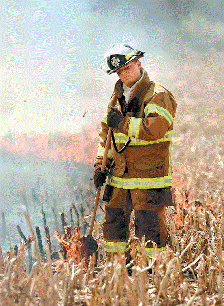
Smoke from a field fire south of Haskins swirls around firefighter Steve Shaner of Washington Township.

Smoke from a field fire south of Haskins swirls around firefighter Steve Shaner of Washington Township.
Dry weather is good for farmers when it occurs during planting season, but not so good in other ways.
And while northwest Ohio and southeast Michigan have been unusually dry since early last month, forecasters said yesterday the weather pattern is about to change, with rain expected beginning today.
In the last seven weeks, National Weather Service records show, just 1.35 inches of precipitation fell at Toledo Express Airport, which is 3.21 inches lower than normal for the period from March 1 to April 18. The last significant rainfall, 0.52 inches, occurred April 2.
Farmers growing corn and soybeans, the region's largest crops, have welcomed the opportunity to begin planting early.
"We've had several customers indicate this is the best start they've ever had," said Chuck Beier, grain purchasing manager for The Andersons in Maumee.

Nine percent of corn for Ohio and Michigan was planted by last weekend, up from a normal 3 percent in Ohio and 1 percent for Michigan by mid-April, according to the National Agricultural Statistics Service.
Mr. Beier estimated that by late yesterday afternoon, 30 to 35 percent of the region's corn and 5 percent of soybean seeds were in the ground.
On the down side, the dry conditions are believed to have contributed to several grass and brush fires, including one in Wood County's Middleton Township yesterday that blackened 22 acres of corn stubble near State Rts. 64 and 295.
Middleton Township and Washington Township firefighters needed about 90 minutes to douse the blaze after being summoned about 12:45 p.m. The fire's cause was not immediately known.
Another outdoor fire was reported yesterday near Bradner, Ohio. On Saturday, a scrap-wood bonfire started by a farmer in Monroe County's Summerfield Township spread to his field of corn stubble and eventually destroyed two barns. It also jumped a road and damaged a shed and destroyed a lawn mower.
Summerfield and Bedford townships had declared bans on outdoor burning last week, but officials conceded that it is hard to enforce, especially at a time of year when residents normally clear agricultural debris with fires and may not realize how dry it has been.
According to the U.S. Drought Monitor program coordinated by several federal agencies, an area encompassing most of the eastern half of lower Michigan and stretching to the extreme northwest corner of Ohio and northeast corner of Indiana was designated as "abnormally dry" as of the last report, based on April 12 data.
But more April-like weather is on the way, according to yesterday's forecasts.
A cold front dropping into the lower Great Lakes from the northwest is likely to bring showers and thunderstorms to the Toledo area late this afternoon and tonight, said Dave Bowers, a meteorologist with AccuWeather, Inc., a private forecasting service based in State College, Pa. Another storm system at the far end of the same front will bring more wet weather Friday night into early Saturday, he said.
"The pattern is changing now. I think we're going to see this dry spell end during the rest of this week," Mr. Bowers said.
Blade staff writer Jane Schmucker contributed to this report.
Contact David Patch at:
dpatch@theblade.com
or 419-724-6094.