Republican-drawn congressional map clears Ohio House amid Democrats' complaints
9/15/2011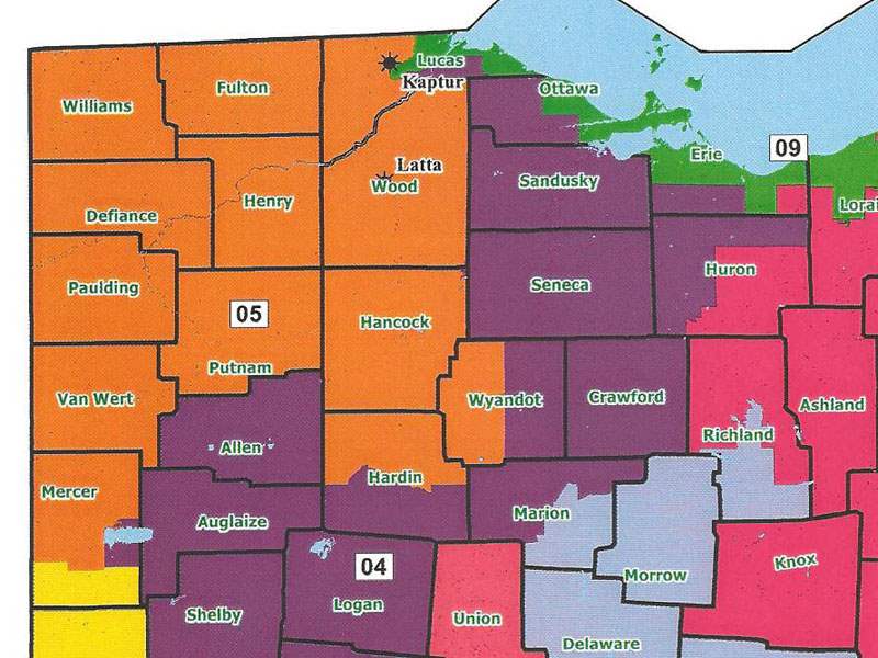

This map shows the proposed redistricting for Ohio's congressional districts. Orange = Bob Latta; Green = Marcy Kaptur; Purple = Jim Jordan.
COLUMBUS — The Ohio House voted 56-36 Thursday to approve a new congressional map that is destined for a court challenge or a potential voter referendum.
The map is expected to come to a vote next week in the Senate where Republicans outnumber Democrats better than 2 to 1.
“Look at what you all did to Toledo,’’ state Rep. Ronald Gerberry (D., Austintown) told the House Republican majority. “What this map does to the city of Toledo is disgraceful.’’
The map that would take effect with 2012 congressional elections would divide Toledo three ways among districts currently represented by U.S. Rep. Marcy Kaptur (D., Toledo), U.S. Rep. Bob Latta (R., Bowling Green), and U.S. Rep. Jim Jordan (R., Urbana).
State Rep. Lynn Wachtmann (R., Napoleon) challenged the suggestion that the split would diminish the political influence of residents of Toledo and Lucas County in Washington.
“Clearly, there are good examples in the state where communities who’ve had multiple congressional officeholders and multiple state legislators have used that to their advantage to gain more momentum by virtue of there are more members working for their efforts,’’ he said.
“Now indeed many in Lucas County, it would be my experience, don’t know what bipartisanship working is,’’ Mr. Wachtmann said. “Frankly, to a large extent, they don’t have to. They can run the railroad down and off the tracks like they do many times with foolish taxation and excessive regulation.’’
The proposed map would create a new 9th District, represented by Ms. Kaptur, that would snake farther east along the Lake Erie shoreline from Toledo to Cleveland, with slivers of Lucas, Ottawa, Erie, Lorain, and Cuyahoga counties along the way. It sets up a potential clash of two Ohio Democratic congressional titans—Ms. Kaptur and U.S. Rep. Dennis Kucinich of Cleveland.
The map drew the support of three Democrats, all African-Americans happy with how the map treats minority districts. Five Republicans opposed it.
Rep. Rex Damschroder (R., Fremont) was among the Republican “no” votes. His House district, now part of Mr. Latta’s 5th District, would become part of Mr. Jordan’s 4th.
“I don’t think the map is in the best interests of northwest Ohio…,’’ he said. “I’ve talked with our party chairmen. They are disappointed. I commend Congressman Latta. He’s been very receptive, and he’s 20 to 30 miles away.
“I know Jim Jordan,’’ Mr. Damschroder said. “I like Jim Jordan. I’ve worked with Jim Jordan. I came into the (Ohio) House with Jim Jordan. He’s a hardworking, great congressman. But he’s also 100 miles away… I wonder, in particular, what Toledo has in common with Clark County 100-some miles south.’’
Ohio Democratic Party Chairman Chris Redfern said the party will not intervene in a 2012 primary election clash between Ms. Kaptur and Mr. Kucinich.
“We’ll see how this thing plays out…,’’ he said. “The person that touches the most people wins, literally. In Toledo, Marcy Kaptur, that’s her strength. On the west side of Cleveland, that’s Dennis Kucinich’s strength.
“This election will be won from Rocky River to Port Clinton,’’ Mr. Redfern said. “The winning candidate will spend more of their time in those communities. It’s not an election you can win on Cleveland television or Toledo television, because frankly in Lorain County or in Sandusky there’s an expectation that there will be retail politics.’’
Democrats are exploring potential court challenges as well as a voter referendum of the bill enacting the revised districts. The federally mandated, once-in-a-decade process redraws districts following each U.S. Census to equalize populations and is traditionally used by the political party in charge to preserve and strengthen its hold.
State Rep. Matt Huffman (R., Lima), the bill’s sponsor, said such a voter referendum to delay implementation of a new map until the November 2012 election would invite a federal court, potentially the 6th Circuit Court of Appeals with judges from four states, to draw Ohio’s map.
Ohio will sacrifice two of its 18 seats in the U.S. House of Representatives because of its sluggish population growth over the last 10 years in comparison to faster growing southern and western states. The GOP map now on its way to a Senate vote creates four solid Democratic districts and 12 districts that are either strongly Republican or lean in that direction.
Before next week’s Senate vote Democrats plan to propose their own map, although Mr. Redfern could offer few details on what it might look like and which two sitting congressmen would likely be out of jobs.
“We are prepared to use every tool, every constitutional resource at our disposal to fight this unfair, anti-voter congressional map….,’’ Mr. Redfern said. “While we’re not surprised that Republicans are again ignoring the will of the people, Republicans should not be surprised when the people of the state fight back.’’