Temperatures likely to hit 50s, then drop again
1/12/2005
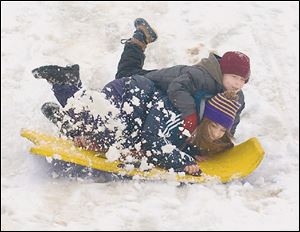
Maumee residents Nicole Figueroa, 14, and Devin Fox, 7, share a ride down an incline at Indian Hills Park. Much of the snow could melt today, as temperatures are expected to reach the middle to upper 50s.
Many Toledo-area residents aren't sure which coat to reach for as they head out the door these days.
Meteorologists, who see the area as a battleground of warring warm and cold fronts, say that quandary likely isn't to be resolved any time soon.
After days of roller-coaster temperatures, today's highs are likely to soar into the 50s.
"It'll be warm - oddly warm," said Mike Dutter, a meteorologist with the National Weather Service, who said while it's unlikely today's temperatures will break Toledo's record for the date of 63 degrees, a warm front from the south could push it close. "I wouldn't be surprised if somewhere across northern Ohio, it gets up to around 60 [today]," Mr. Dutter said. "It's a pretty dynamic system."
But what goes up .●.●.
"Will go down, down, down on Thursday," said Henry Margusity, a meteorologist with AccuWeather Inc., a private forecasting service based in State College, Pa. "It will probably be snowing by the end of the day."
A burst of arctic air from Canada will sweep down on the area at mid-day tomorrow, so those who fail to take their parkas for the 50-degree morning drive will be met with 30-degree temperatures on their ride home.
As for tomorrow night, temperatures could dip down to 13 - and stay in the teens Friday.
Why can't the region's thermometers seem to make up their minds these days?
"Toledo's on the battleground this year between warm and cold fronts," Mr. Margusity said.
Arctic air from the north is in constant conflict with a particularly persistent ridge of high pressure in the southern part of the country, producing warm fronts from that direction.
"The two [sources] have been fighting it out right over the top of us," Mr. Margusity said.
The swirling fronts also have led to spotty precipitation, as well. Yesterday, for instance, Toledo received only 1 1/2 inches of snow. Just across the state line, residents in Blissfield had three times as much.
Precipitation also may be a problem, with possible thunderstorms today and more rain tomorrow creating about an inch of total rainfall. That, coupled with melting snow, could create standing water in the Toledo area, which remains in a flood watch, Mr. Dutter said.
That standing water would then freeze come Friday.
Many area residents are still recovering from an assault of ice. More than 6,000 residents in northwest Ohio - 5,000 of them in Lima - remained without power yesterday, local power companies reported.
American Electric Power and Midwest Power, the primary electricity providers in the area, expect most power to be restored by midnight Thursday.