Rain-inundated rivers threaten NW Ohio
2/7/2008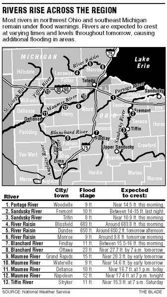
 Flooding in region " rel="storyimage1" title="Rain-inundated-rivers-threaten-NW-Ohio.jpg"/>
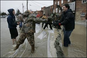
Kari Sweeney tosses a sandbag to fellow Eastwood High School student Alex Hernandez. (THE BLADE/DAVE ZAPOTOSKY) <br> <img src=http://www.toledoblade.com/graphics/icons/photo.gif> <b><font color=red>VIEW</b></font color=red>: <a href=" /apps/pbcs.dll/gallery?Avis=TO&Dato=20080207&Kategori=NEWS12&Lopenr=520661654&Ref=PH" target="_blank "><b>Flooding in region</b></a>
Rain-swollen rivers across northwest Ohio and southeast Michigan continued to rise yesterday after a second night of downpours swept through the region, but for the most part, flooding was not expected to be as severe as it was in Findlay.
In Pemberville, Eastwood High School students helped firefighters fill sandbags at the rising Portage River.
In Grand Rapids, merchants braced for a Maumee River crest that wasn't expected to arrive until tomorrow morning.
Less significant flooding was expected along other rivers, including the Tiffin, Sandusky, and Huron, but even in those basins the water was high enough to inundate farmland and close roads.
Authorities said a Willard, Ohio, woman nearly drowned when she tried to drive through floodwaters on a Sandusky County road and her car was swept away.
Bellevue firefighters responding to a 6:40 a.m. 911 call from Christina M. Laughlin, 32, found her car submerged in a field off County Road 32 in Thompson Township and rescued her before an air pocket in the car ran out.
Throughout the region, officials warned other motorists to avoid driving on flooded roads, noting that just a foot of water can make a car float.

By early evening, heavy rain had moved out of the region, with remaining precipitation mixing with sleet and then changing to a quick dusting of snow.
In Grand Rapids, the Maumee was 1.8 feet above its 15-foot flood stage by midafternoon, and forecast to rise 3 1/2 feet more before cresting early tomorrow morning.
But many downtown Grand Rapids merchants were prepared to roll with Mother Nature's punch, noting that winter flooding is not unusual in their community. Several shop owners said they hadn't made any special preparations, such as moving goods to higher shelves.
Terri Elling, co-owner of The Garden Gate, 24192 Front St., said her building sits 21 feet, 8 inches away from the river - about 1 1/2 feet above the crest predicted for Friday morning - and she expected business as usual today.
If need be, Ms. Elling planned to move plants and other merchandise onto plywood and cinder blocks.
"Hopefully, it's not going to come to that," she said. "We're all on standby."
But village residents had been in to stock up on bread, milk, and ground beef "just in case," she said.
Upstream in Napoleon and downstream in Waterville, officials kept a wary eye on river forecasts but did not anticipate substantial problems.
"We do have some flooding in our parks and things, but that's the way it's designed," said Jon Bisher, Napoleon's city manager. The downtown area is on high ground, he said, and the low-lying sewage treatment plant is protected by dikes.
Waterville Fire Chief Steve Parsons, meanwhile, said that as long as the river doesn't go higher than a predicted 14.6-foot crest, flooding wouldn't be a big problem.
The Maumee was at 12.1 feet by yesterday afternoon in Waterville and expected to crest Friday morning.
Chief Parsons, formerly the Grand Rapids fire chief , said many floods hit Grand Rapids harder, even though it and Waterville are only about seven miles apart, because the river is narrower and has less floodplain near Grand Rapids than near Waterville.
As of 5 p.m., the National Weather Service reported rainfalls exceeding 2 inches had fallen throughout northwest Ohio during the previous 48 hours as a pair of storm systems drew warm, moist air north from the Gulf of Mexico.
The highest official rainfall was in Lima, where 3.37 inches fell, while 2.75 inches was recorded in Findlay and 2.82 inches in Defiance.
The 48-hour total at Toledo Express Airport was 2.19 inches, bringing the monthly precipitation to 2.85 inches - more than seven times the average local precipitation for the first week of February.
In much of the region, the rain fell from a weaker storm that passed through the area over the weekend. With the ground frozen underneath, the rain and melting ice and snow primarily ran off into rivers and streams rather than soaking into the soil. Chief Parsons said subsurface frost probably kept some water from reaching drainage tiles that feed into the streams.
Significant flooding also occurred in northeastern and central Ohio.
The Ohio Department of Transportation reported that 88 state or federal highways were closed for at least part of the day.
Rainfall totals in southeast Michigan were lower than those in neighboring Ohio, but enough to cause minor flooding on the River Raisin. It was expected to rise less than a foot above its flood stages in Monroe and Dundee today and tomorrow, respectively, but was subject to ice jams that could cause rapid changes.
In Blissfield, the River Raisin flooded and was expected to crest this morning about 10 inches above flood stage.
In Pemberville, where the Portage has been a recurring source of flood problems, officials watched the water rise and wondered if a permanent solution would ever be within reach.
"The biggest problem, like always, is money," Pemberville Mayor James Opelt said. "We need millions of dollars to fix a problem that happens every three or four years."
Firefighters and volunteers, including about 73 Eastwood High School students, filled sandbags and stacked them behind businesses that back up to the Portage.
Eastwood senior Nick Eckel admitted he offered to help out both to get out of school for the day and to help his neighbors. In addition to handling sandbags, he helped residents in flood-prone homes move furniture and other belongings to higher ground.
Mackenzie Liko, also a senior, said initially only boys were asked to help, but the girls insisted they could work just as hard and soon were excused from school as well.
"I wanted to help," she said. "We live here."
Pemberville Councilman Dave Miesmer, who was watching the efforts, said he's not so sure his village ever will resolve the age-old flooding problem.
"How do you stop Mother Nature?" he asked. "If you think you can, you're fooling yourself."
Flooding was not limited to major rivers. In Oregon, Wolf Creek flooded farms and roads and backed up sewer lines in what Director of Public Service Paul Roman said was one of the worst he's experienced as director.
"It's in the top five of floods that I've seen since I've been here," he said.
Blade staff writers Kate Giammarise and Chauncey Alcorn contributed to this report.
Contact David Patch at:
dpatch@theblade.com
or 419-724-6094.