Lines, tunnels below mean trouble above
12/25/2004
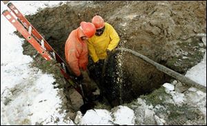
City workers Sam Loy and Sam Basil work on a broken water main on Winnette Drive during a cold Thursday afternoon.
What's buried beneath? It's not a horror movie title but rather a terrifying question for workers considering ripping into a city street with a backhoe.
The murky unknown beneath the asphalt, concrete, and grass holds secrets - tunnels and pipes - sometimes decades, maybe even a century-or-more old.
And with the advents of cable and fiber-optic technologies, it's getting more crowded each year.
Case in point is a plan to build an amphitheater on Promenade Park on the banks of the Maumee. One of the concerns, though, is that a full mapping of the various pipes, tunnels, and lines underground would have to be completed before moving forward.
Such comprehensive charts do not exist, and rerouting lines for a project can be expensive, city officials said.
In public rights of way, in urban settings, the lines are many.
"There are [natural] gas lines, petroleum lines, fiber optics, Edison [power lines], cable TV, telephone lines, along with sewer mains. You could end up hitting storm sewer on top of all of that," Don Czerniak, president of American Federation of State, County, and Municipal Employees Local 7, said. "In subdivisions, you could end up hitting a sump-pump line running out to the street too," Mr. Czerniak said. "There can be septic tanks in people's yards."
He understands this first-hand.
Mr. Czerniak was operating a backhoe for the Toledo water department Dec. 5 when he punctured a pressurized gas line. He was ripping into the road to repair a broken water main and punctured the gas line, which behaved like an overheated car radiator exploding.
The line was not properly marked by Columbia Gas of Ohio.
The force of the rushing gas sounded like a jet engine as it roared, lifting his backhoe momentarily off the ground and prompting the evacuation of a nearby shopping center. Police shut down Holland-Sylvania Road from Airport Highway to Angola Road.
"Backhoe operators have been blown up and killed hitting gas lines [outside of this area], and millions of dollars in fiber optics have been cut. It's an ungodly amount of money when it's fiber optic, something like $5,000 a strand," he said.
Avoiding the web of lines and tunnels that run underground to power the world above would require a map of Treasure Island proportions.
But such a map does not exist, and when a new development project comes up for approval by the city, the Toledo Plan Commission staff sends out the plans to the various utilities for separate approvals.
Steve Herwat, director of Toledo Plan Commission, said the utilities and developers together chart out how to move or avoid lines.
He said there is no set method for placing lines into the easement or right-of-way and that it can be a haphazard placement of different lines.
"They are all located within the public right of way, and there's no dedicated system," he said.
Utilities are required to mark off where the lines exist, all part of a nervous choreography of cooperation that doesn't always work.
The dance instructor is the Ohio Utilities Protection Service, also referred to as OUPS. The agency acts as a clearinghouse for requests to have lines marked.
Even when the system works well, identifying exactly where some lines run has become challenging as roads and other traditional markers shift over time.
Some maps have gotten out of whack, Gina Thompson, communications manager for Columbia Gas of Ohio, said.
"Some of the lines we have are 40 to 50 years old, and a lot of the measurements where the lines are located are based on old information. We don't get the information. We widened the road by two feet, so our measurements are off," she said. "Airport Highway used to be a two-lane road. Now it's a four to five-lane highway. You had a line that ran along the side of street, and now it's in the middle of the highway. It's very challenging when you are updating your maps."
Ms. Thompson said Columbia is creating a digital database of exactly where all of its 1,964 miles of pipeline that serves 175,000 customers are. Columbia Gas has 27,000 requests a year to mark off gas line location so a family can plant a tree or a developer can build.
"We've come a long way from the process we used to use. We used to have those 24 by 36 maps. They'd have to actually etch in and draw in the lines. Over the last three to five years we've used this Autocad system. It's our electronic mapping system."
Mr. Czerniak said one of the problems comes from utilities using outside contractors to build new lines. Sometimes the companies are sloppy about mapping or they simply fail to supply the information, he said.
The result is sometimes dangerous but mostly annoying situations that every so often can close a shopping center, evacuate a school, or close down a road.
Contact Christopher D. Kirkpatrick
at: ckirkpatrick@theblade.com
or 419-724-6077.