Wood County twister's winds pegged at 135 to 165 mph
6/7/2010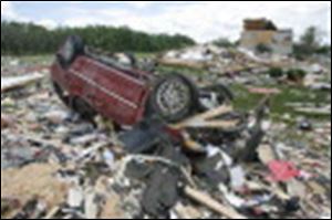 Path of Tornado June 7, 2010
Debris and an overturned vehicle litter the lawn in the area of what was a home on Main Street in Millbury after a tornado hit." rel="storyimage1" title="Wood-County-twister-s-winds-pegged-at-135-to-165-mph.jpg"/>
<img src=http://www.toledoblade.com/assets/jpg/TO66067417.JPG> <b><font color=red>VIEW:</b></font color=red> <a href="/assets/pdf/TO7244167.PDF" target="_blank "><b>Path of Tornado</b></a> June 7, 2010 <br><br> Debris and an overturned vehicle litter the lawn in the area of what was a home on Main Street in Millbury after a tornado hit.
The deadly tornado that struck northern Wood County late Saturday evening packed winds estimated at least between 135 and 165 miles per hour and was on the ground for 8 to 10 miles, according to a preliminary report issued Sunday by the National Weather Service in Cleveland.
And Frank Kieltyka, an agency meteorologist, said the EF-3 "severe" rating on the Enhanced Fujita scale could be moved higher pending further study.
The Wood County tornado was one of five that the National Weather Service confirmed from a complex of thunderstorms that raked the Toledo area late Saturday and early yesterday, including one in eastern Fulton and western Lucas counties and three in southeast Michigan.
The twister that killed seven people in Lake Township and Millbury and destroyed Lake High School was the strongest, while the tornadoes that struck southeast of Delta and in and near Dundee, Mich., were next, receiving EF-2 ratings, the next lowest on the scale.
The tornado first touched down near Oregon Road and the Ohio Turnpike, then roughly followed State Rt. 795 eastward before jogging slightly to the northeast, Mr. Kieltyka said.
It crossed the northwest part of Millbury before entering Ottawa County, where it followed Trowbridge Road before lifting just west of Clay Center.
It was on the ground for about 15 minutes, starting at about
11:15 p.m., and was about 200 to 300 yards wide, Mr. Kieltyka said.
The Dundee tornado was much wider - about 800 yards, or nearly half a mile at its peak, according to the National Weather Service office in White Lake, Mich. - but its top winds were slightly weaker, estimated between 130 and 135 mph.
It started near County Line and Rankin roads at about 2:11 a.m. and reached Dundee six minutes later, gaining its peak strength as it reached the western edge of town near Cabela's and the Splash City water park.
It still packed winds of 115 mph as it passed through the village, then weakened as it continued east another seven miles along M-50 before lifting near Dixon Road, the weather service said.
Two separate - and weaker - twisters were responsible for damage near Rome Center in Lenawee County and at the Fermi 2 Nuclear Power Station northeast of Monroe.
The Rome Center tornado was on the ground for only four minutes and covered 2.5 miles from Southard Highway and Woerner Road to Springville Highway.
Its top speed was estimated at 90 mph, the same as for the tornado that formed at 2:33 a.m. southwest of Detroit Beach and traveled for five miles northeast before entering Lake Erie at Estral Beach six minutes later, the weather service said.
The Fulton County tornado, believed to have touched down at about 10:30 p.m., started near County Road A and State Rt. 109 and headed east for about 7.5 miles, according to the National Weather Service office in North Webster, Ind.
That storm weakened as it entered Lucas County but was still strong enough to fell trees in and near Oak Openings Preserve Metropark.
Contact David Patch at:
dpatch@theblade.com
or 419-724-6094.