NORTHWEST OHIO WATERSHED OVERFLOWS OFTEN
Blanchard River control far in future for Findlay, Ottawa
Work remains unlikely to start until ’17
1/7/2013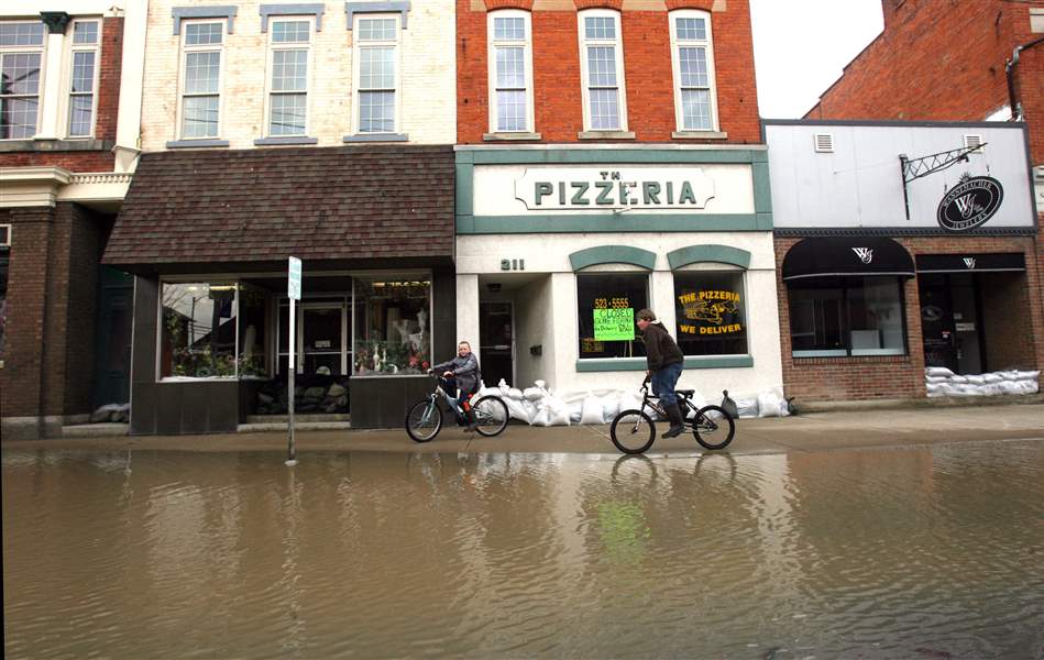
Children ride their bikes through flooded Main Street in Ottawa, Ohio, in 2009, one of several occurrences of the Blanchard overflowing into the town.
The Blade/Amy E. Voigt
Buy This Image

Heavy rains that mixed with melting snow pushed the Blanchard River over its banks, flooding Ottawa, Ohio, in March, 2011. The scene is familiar to area residents; devastating floods have hit the watershed area repeatedly, causing millions of dollars’ worth of property losses.
FINDLAY — Years after several devastating floods hit Findlay and Ottawa, local officials are working with the U.S. Army Corps of Engineers for solutions to contain the Blanchard River.
The news so far isn’t good: Proposed solutions to alleviate flooding are expected to cost $150 million or more, funding is uncertain, and any construction would not begin until at least 2017.
The most immediate concern is whether the federal government will provide the $1.7 million needed to complete the last phase of the watershed study. If not, regional governments would have to come up with the money. The study, in its second phase, is funded through 2013.
“If they can’t get $1.7 million more for the study, this project goes up on the shelf,” said Steve Oman, chairman of Concerned Property Owners in the Blanchard River Watershed. Mr. Oman, a former Hancock County commissioner, has been an outspoken critic of the study and proposed flood solutions.
He was among hundreds of residents who attended community meetings in December held by the Army Corps of Engineers. The sessions aimed to gave residents a chance to learn about possible plans to address flooding problems and offer feedback.
Judy McCrory of Findlay, who attended one meeting, said the lack of anything new disappointed her. The proposals were the same ones made two years ago, she said.
“I’ve learned not to pay a lot of attention to the proposals,” she said. “I’m taking a wait-and-see approach.”
Officials said during the meetings that several obstacles, including funding, exist, and the study process is a long one.
Jeff Loehrke, Ottawa’s community development director, said community leaders share residents’ frustration. He urged the community to be patient so the best possible plans could be found. “We’re somewhat frustrated with the length of time it’s taken,” Mr. Loehrke said. “But, we all want to make sure that smart engineering principles are used to best resolve problems.
“If we went out and tried something with no real engineering [to back it up], we would be accountable.”
Phil Berkeley, chief planner with the Corps of Engineers’ Buffalo district, previously has said that on average, a major flood-control project takes 10 years after the required studies begin.

The meetings are part of the process required before federal funding can be requested, Mike Pniewski, a corps project manager, said. Although similar to previous versions, the proposals presented during the meetings included some modifications, he said.
He did not specify what they were.
The public has until Thursday to submit opinions about the flood-control proposals. Comments may be sent by email to Blanchard.nepa@ usace.army.mil, or by regular mail to U.S. Army Corps of Engineers, Buffalo District Environmental Analysis Team, 1776 Niagara St., Buffalo, N.Y., 14207-3199.
The feedback will be used to formulate the final plan, Mr. Pniewski said.
To combat flooding along Eagle Creek, the Corps of Engineers has proposed building a 9.3-mile diversion channel that would redirect floodwater from a point in Eagle Township near Hancock County Road 40 around the west side of Findlay to an outfall on the Blanchard River in Liberty Township near Township Roads 89 and 130.
An alternative version would use Aurand Run, also west of Findlay, to handle Eagle Creek overflow, although building a retention pond along Eagle Creek south of County Road 40 is also under consideration.
Residents such as Mr. Oman say one of their biggest concerns is that diverting floodwaters won’t stop flooding but merely redistribute it to other communities.
“Everyone thinks this is going to stop the [level of flooding that occurred in 2007],” said Mr. Oman. “That’s not going to happen ... there’s going to be other places flooding. The bottom line: Unless they can take care of the current infrastructure, not a lot’s going to happen.”
The Corps of Engineers has repeatedly told community leaders that no plan will eliminate flooding problems. The proposed solutions are designed to prevent a major catastrophe such as the 2007 flood, which caused about $100 million in damage in Findlay and $20 million in Ottawa.
Other areas would remain subject to severe flooding, officials said.
Camp Berry, a Boy Scout camp on the north side of County Road 40, would be near either proposed channel and would be vulnerable to high water, particularly at a cabin near the creek, Mr. Pniewski said.
Another issue, officials said, is Findlay’s drinking-water reservoirs in Marion Township, which are in a flood-prone area.
When the Blanchard River floods, excess water flows into Lye Creek, which leads to the city and causes flooding there.
In 2007, flood peaks in the creeks and rivers occurred within an hour, which worsened flooding conditions, Mr. Pniewski said.
Another recommendation is to build a levee along the river from the reservoir to state Rt. 15. The levee would prevent the river and Lye Creek from meeting there — lower the peak flow in Lyle Creek — and slow the river’s peak by forcing it to go around the east and north sides of the reservoirs.

Children ride their bikes through flooded Main Street in Ottawa, Ohio, in 2009, one of several occurrences of the Blanchard overflowing into the town.
The action would result in “induced flooding” in two Findlay neighborhoods where the river level would rise at least 2.5 inches during floods, according to officials. Those two neighborhoods would be included in “nonstructural mitigation areas” and could involve some government property purchases and the elevation of flood-prone homes and businesses.
Officials say they won’t have specifics on the number of homes to be affected until more elevation studies are conducted. That will be part of the next study.
Another proposed step is to replace a railroad bridge over the Blanchard on the northwest side of downtown Findlay that chokes the river during floods, causing water to back up upstream, Mr. Pniewski said. The Norfolk Southern bridge is more than 100 years old.
Farther downstream, between Findlay and Ottawa, the Corps of Engineers has proposed four water-retention areas — two between State Rts. 186 and 235, one just west of Rt. 235, and one just east of Ottawa and south of U.S. 224.
Plans in Ottawa call to modify the Putnam County Road I-9 bridge west of the village and realign the river so it flows more directly to the bridge.
The diversion channels would shorten flow path and pull flood waters away from Ottawa, according to officials. Cost estimates range between $7 million and $10 million, and they would require condemning about 180 acres of farmland that would be cut off by the diversion channel.
Ottawa’s village council last week endorsed the Corps of Engineers’ efforts, directing Mayor J. Dean Meyer to send a letter to the corps stating its support.
The letter read: “Since the devastating flood of August, 2007, Ottawa Council has maintained a position that a ‘no action alternative’ to flood mitigation is not an acceptable plan. We believe the four risk-management plans presented to the public in December have merit and should be further studied.”
Not everyone is happy.
Several farmers, including Mr. Oman, say they are frustrated because their concerns about losing valuable farmland haven’t been addressed. They stand to lose hundreds of thousands of dollars if the diversion channels are built, Mr. Oman said.
“They have totally left agriculture out of the loop on this,” Mr. Oman said. “They know there’s not one penny to gain for farmers. We’re going to lose.”
Flood control could be more effective if the current river were dredged and fallen trees and other debris removed from it, he said.
“The problem is that the current leadership doesn’t understand agriculture,” Mr. Oman said. “Nobody wants to step up to the plate and do something about the river. All you’re doing is moving the flooding.”
Contact Federico Martinez at: fmartinez@theblade.com or 419-724-6154.