Maumee River overflows in Waterville
1 death reported as rain floods area streets, parks, basements
1/14/2013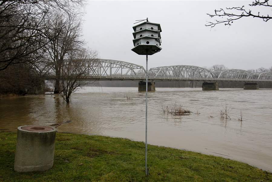
Portions of Memorial Park and the surrounding lowlands were submerged Sunday as the Maumee River crested its banks in Waterville. The National Weather Service has issued flood warnings.
THE BLADE/KATIE RAUSCH
Buy This Image

Portions of Memorial Park and the surrounding lowlands were submerged Sunday as the Maumee River crested its banks in Waterville. The National Weather Service has issued flood warnings.
WAUSEON — High water left over from the rain that fell during the weekend apparently caused at least one death Sunday when a car driven by an Archbold, Ohio, man went into a water-filled ditch in Fulton County’s Clinton Township.
The Ohio Highway Patrol said Michael Rocha was driving southbound on County Road 15, south of County Road C along the Wauseon Reservoir near Wauseon, when his car went off the left side of the roadway and overturned into the ditch, troopers with the Toledo post said.
A passer-by saw the vehicle and reported it to law enforcement officials about 11 a.m. Sunday.
Mr. Rocha was pronounced dead at the scene, troopers said. He was not wearing a safety belt.
It is not yet known what time or day the crash occurred. The crash remains under investigation.
In Toledo, flooding closed several streets, including Berdan Avenue west of Douglas. Central Avenue in Sylvania Township was closed eastbound at Reynolds Road and westbound at Corey Road by the Ohio Department of Transportation Sunday morning because of high water.
Township police said the street was reopened.
Jen Sorgenfrei, spokesman for the city of Toledo, said several streets in the city experienced flooding Sunday. Some of the high water could be attributed to frozen leaves clogging sewer grates, she said, although the intensity of the rain, coupled with the frozen ground, also were to blame.
Residents reported flooded basements in several neighborhoods, she said, although a specific number of calls was not immediately available.
Residents who experience flooding or high-water issues were asked to call the city’s 24-hour nonemergency line, 419-936-2020, to report problems.

The Maumee River crested its banks and surged into low-lying surrounding areas Sunday afternoon in Waterville. The river was expected to continue to rise through Tuesday.
The “Call City Hall” line is answered by an operator, unless the volume is too great and the calls are shunted to a recording, she said.
The weather service said flooding was likely in some lowland areas in northwest Ohio, such as along the Maumee River in Waterville and Grand Rapids.
Total rainfall ranged from 1½ to 2½ inches, according to the National Weather Service, which has issued flood warnings for several areas in Ohio.
The Maumee River at Waterville crested at at 8.3 feet Sunday; flood stage is 9 feet. The river was expected to rise to near 11.1 feet by early Tuesday morning.
At 12 feet, residences along the river may experience basement flooding. Parks near the river in the Waterville and Maumee areas could experience flooding as well as other lowland areas near the river, according to the weather service.
A flood warning was issued for the Maumee River near Grand Rapids, where the river was at 11.8 feet; flood stage is 15 feet. Minor flooding was forecast.
The river, according to the National Weather Service, would continue to rise to near 15.5 feet by Monday night.
At 16.5 feet, Thurston State Park would flood, and at 15 feet lowland flooding would occur near Grand Rapids and along secondary roads in the area.
Flood warnings also have been issued for the Portage River at Woodville and the Blanchard River near Findlay, and in addition, the National Weather Service has issued a flood watch for several portions of northwest Ohio, including in Hancock, Lucas, Ottawa, Sandusky, Seneca, Wood, and Wyandot counties until Sunday evening.
Low-lying areas and small streams experienced high water in many places. Residents and businesses near waterways should be on the alert for rising water today, according to the weather service, because of high water.
The National Weather Service also issued a flood warning for Eagle Creek in Findlay. Mnor flooding was reported and forecasters said the river could reach 9.5 feet by Monday morning, overrun its banks, and cover Fremont and Graceland avenues.