Flood watches posted for Toledo, most of surrounding area
2/19/2018
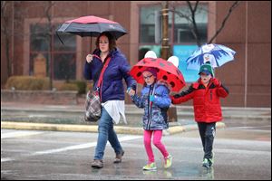
Nicole Sobieski and her children, Rhiannon, 8, and Jacob, 6, of Allen Park, Mich., dodge raindrops and puddles as they cross Summit Street en-route to the Imagination Station Monday, February 19, in Toledo.
Flood watches were posted Monday for significant parts of the Toledo area in anticipation of sustained, soaking rain through midweek.
A watch for Lucas, Wood, and Ottawa counties took effect at noon Monday and was expanded later in the day to include Sandusky, Hancock, and Seneca counties after about an inch of rain fell in the region, according to the National Weather Service office in Cleveland. Similar advisories were posted for areas west and north of Toledo, and all were scheduled to be in effect until 4 p.m. Wednesday.
RELATED: Flood warnings issued for area rivers
The Cleveland office said another quarter-inch to half-inch would fall by Tuesday morning, followed by an additional inch or so between then and Wednesday afternoon.
“Excessive rainfall may lead to flooding of streams, creeks, low-lying spots, and poor-drainage areas, especially in urban and hilly locations,” forecasters said. “Those near streams and rivers should be especially cautious as streams and rivers can rise quickly,” forecasters said.
Gusty wind and record warmth also are forecast to be part of the mix Tuesday, with a Toledo high in the upper 60s likely to eclipse the date’s 66-degree record from 1930.
Jay Berschback, chief meteorologist with WTVG-TV, Channel 13, said a “record high low” of 48 degrees, also set on Feb. 20, 1930, is likely to fall as well, with an expected morning low temperature at Toledo Express Airport as high as 60 degrees.
A flood warning was already in effect for several rivers in far northwest Ohio.
The Tiffin River, already 0.7 feet above its 11-foot flood stage in Stryker, Ohio, was forecast to cause major flooding in that area, with a crest at 16.7 feet forecast to occur just after midnight Saturday morning.
The St. Joseph River, which flows across Williams County and clips Defiance County, also is forecast for moderate to major flooding.
Moderate flooding was predicted for the Maumee River in Paulding County. The Maumee was forecast to rise above its 17-foot flood stage in Fort Wayne, Ind., by Tuesday evening and crest around 23 feet early Friday. A 23-foot crest would be just shy of major flooding and exceed the 22.9-foot crest from a flood there 10 years ago, the National Weather Service office in North Webster, Ind., said.
The North Webster office predicted 2 to 4 inches of rain in its flood-watch area including Fulton, Henry, Williams, Defiance, Paulding, Putnam, Van Wert, and Allen counties in Ohio and Hillsdale County in Michigan. The flood watch for Monroe, Lenawee, and adjoining Michigan counties to the north, issued by the White Lake office, predicted 1 to 3 inches in that zone combined with runoff from melting snow.
Mr. Berschback said the persistent rain is the result of a moist flow of fast-moving air from the southwest that is tapping the Gulf of Mexico. The same wind pattern is bringing unusually cold air to the western United States, he said.
The heaviest rain should push north and west of Toledo during the day Tuesday, Mr. Berschback said. That would increase Toledo’s chance of a record high temperature while areas that got more snow from a winter storm last week have to cope with a greater amount of moisture.
In Toledo, fallen leaves left uncollected because of winter weather’s early December arrival — and persistence since then — could aggravate street flooding by clogging storm drains.
Ignazio Messina, a city spokesman, said leaf collection will resume Tuesday to address “a very small amount of streets” — five or six — in the 43615 ZIP code area; uncurbed streets in the 43606 zone, and several neighborhoods in the 43614 zone.
“A foreman or foremen will also be going back to inspect other ZIP codes to note any leaves that need cleaned up,” Mr. Messina said.
The storm’s back side Wednesday night was forecast to bring a brief period of snow to Toledo.
Long-range forecasts suggest the region will get a brief break from the wet weather on Thursday, but then more rain is predicted for Friday, Saturday, and Sunday following a period of snow showers Thursday night.
Contact David Patch at: dpatch@theblade.com or 419-724-6094.